


وصف لـ Traffic Info and Traffic Alert
Avoid traffic jams:
- Plug-Ins: Integrate external maps and information sources
- Save different destination for navigation
- Traffic map based on google real-time traffic
- Auto-update traffic map every 3 minutes
- Store multiple routes and regions
- Start google map navigation out of traffic map
- Initiate navigation around traffic jam
- Track your position
- Find routes or regions by geocoding
- Best suited for commuters
<b>
Quick Start Guide
==============
(1) Define --> (2) Save --> (3) Load ...
</b>
Manual
======
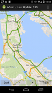
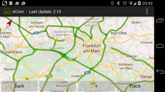
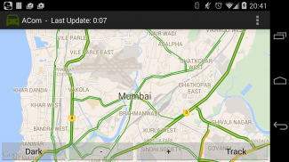
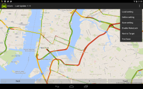
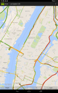
This app called “ACom” presents current traffic information on a map. After starting this app, the map is automatically drawn. Green lines indicate free traffic flow, whereas red lines indicate traffic jam. However, you must be online to receive current information.
<b>The app does not require location information at any time. </b> However, if you want to be tracked, you must enable GPS or WiFi-location in Android. Pressing the “Track”-button will initiate the tracking process. After pressing the “Track”-button, you can press “Bird” to activate the “Birdview”-Mode. (Using “Birdview” with GPS the map is always shown according to your driving direction. Using “Birdview” with WiFi-based location tracking the map is always shown centered to your current position). Pressing the “HideMe”-button will stop the tracking.
You can select WiFi-based location (low energy) or GPS-based location (high energy consumption) via your Android settings menu. Both types of location are supported by ACom. However, we do not recommend using GPS-based tracking without plugged power-supply due to high energy consumption.
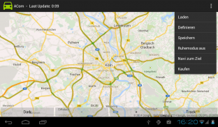
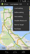
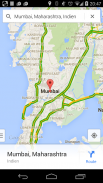
You can define your region of interest (ROI) by selecting the options menu “Define”. A ROI can be a region within to locations or just a single location (city). However, you must be online to define ROIs.
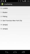
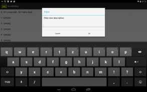
You can store any current presented map just by selecting the options menu “Save”. The title of this storage is automatically generated but can be modified by a “long-click” on the issue.
You can load any stored map just by selecting the options menu “Load” and selecting the desired title.
Smartphones may turn-off automatically after a time (sleep-mode). To avoid that, you can disable the sleep-mode by selecting “Sleep-Mode off” in the options-menu.
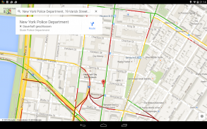
If you have loaded a stored map you can select “Navi to Target” in order to start the google maps navigation app. The navigation target is automatically adopted by the target (city) of your yet defined map.
On the top left side, you can open the “navigation drawer”. The “Master Map” is the main map, which contains all the information. However, you can download third-party Plug-Ins or even a collection of Plug-Ins, which utilize this information and present additional information.
You are free to develop and maintain your own Plug-In. A manual and demos for creating Plug-Ins are available in the github repository grabowCommuter/PlugIn-Developer.
The number of maintained Plug-Ins is limited to 4 in the free version. You can select “purchase” (In-App billing) in the options-menu to overcome this limitation.
</div> <div jsname="WJz9Hc" style="display:none">تجنب الاختناقات المرورية:
- بلج إنس: دمج خرائط الخارجية ومصادر المعلومات
- حفظ جهة مختلفة للملاحة
- خريطة حركة المرور على أساس جوجل حركة المرور في الوقت الحقيقي
- خريطة حركة التحديث التلقائي كل 3 دقائق
- مخزن متعددة الطرق والمناطق
- ابدأ جوجل خريطة الملاحة من خريطة حركة المرور
- بدء الملاحة في جميع أنحاء ازدحام المرور
- تتبع موقفكم
- البحث عن طرق أو المناطق التي كتبها الترميز الجغرافي
- أفضل مناسبة للركاب
دليل البدء السريع
==============
(1) تحديد -> (2) حفظ -> (3) تحميل ...
كتيب
======
ودعا "ACOM" هذا التطبيق يقدم معلومات عن حركة المرور الحالية على الخريطة. بعد بدء هذا التطبيق، ويوجه الخريطة تلقائيا. خطوط خضراء تشير إلى تدفق حركة المرور الحر، في حين أن الخطوط الحمراء تشير إلى ازدحام حركة المرور. ومع ذلك، يجب أن تكون على الانترنت في الحصول على المعلومات الحالية.
لا يتطلب التطبيق معلومات الموقع في أي وقت. ومع ذلك، إذا كنت تريد أن تتبع، يجب تمكين GPS أو واي فاي مكان في الروبوت. والضغط على "المسار" -button بدء عملية تتبع. بعد الضغط على "المسار" -button، يمكنك الضغط على "الطائر" لتفعيل "Birdview" -Mode. (عن طريق "Birdview" مع نظام تحديد المواقع خريطة يظهر دائما وفقا لتوجيهات القيادة الخاصة بك. عن طريق "Birdview" مع موقع القائم على واي فاي تتبع الخريطة يظهر دائما تركز على وضعك الحالي). والضغط على "HideMe" -button وقف تتبع.
يمكنك اختيار الموقع بناء واي فاي (الطاقة المنخفضة) أو موقع على أساس GPS (ارتفاع استهلاك الطاقة) من خلال القائمة الخاصة بك إعدادات الروبوت. ويدعم كلا النوعين من الموقع عن طريق ACOM. ومع ذلك، فإننا لا ننصح باستخدام تتبع المستندة GPS دون توصيل امدادات الطاقة بسبب زيادة استهلاك الطاقة.
يمكنك تحديد منطقة اهتمامك (ROI) عن طريق اختيار قائمة الخيارات "تعريف". A ROI يمكن أن تكون المنطقة داخل لمواقع أو مجرد مكان واحد (المدينة). ومع ذلك، يجب أن تكون على الانترنت لتحديد رويس.
يمكنك تخزين أي خريطة قدم الحالية فقط عن طريق اختيار قائمة الخيارات "حفظ". يتم إنشاء عنوان هذا التخزين تلقائيا ولكن يمكن تعديلها من قبل "طويلة مزدوجا فوق" حول هذه المسألة.
يمكنك تحميل أي خريطة المخزنة فقط عن طريق اختيار قائمة الخيارات "تحميل" واختيار العنوان المطلوب.
الهواتف الذكية قد تتحول قبالة تلقائيا بعد فترة زمنية (النوم واسطة). لتجنب ذلك، يمكنك تعطيل النوم الوضع عن طريق اختيار "النوم في الوضع قبالة" في-قائمة الخيارات.
إذا كنت قد حملت خريطة المخزنة يمكنك تحديد "نافي إلى الهدف" من أجل البدء في الملاحة التطبيق خرائط جوجل. واعتمدت الهدف الملاحة تلقائيا بواسطة هدف (المدينة) من خريطة الخاص بك حتى الآن محددة.
على الجانب الأيسر العلوي، يمكنك فتح "درج التنقل". "سيد خريطة" هي الخريطة الرئيسية، والتي تحتوي على كافة المعلومات. ومع ذلك، يمكنك تحميل طرف ثالث المكونات الإضافية أو حتى مجموعة من المكونات الإضافية، التي تستخدم هذه المعلومات ومعلومات إضافية الحالية.
أنت حر في تطوير وصيانة بنفسك المكونات في. هي دليل والعروض لإنشاء بلج إنس متاح في جيثب مستودع grabowCommuter / المساعد-المطور.
عدد حافظت بلج إنس يقتصر على 4 في نسخة مجانية. يمكنك اختيار "شراء" (في التطبيق الفواتير) في-قائمة الخيارات للتغلب على هذا القيد.</div> <div class="show-more-end">
Traffic Info and Traffic Alert - إصدار 7.8
(03-08-2023)Traffic Info and Traffic Alert - معلومات APK
نُسخة APK: 7.8الحزمة: com.grabow.commuterتطبيقات من الفئة نفسها
قد يعجبك أيضًا...


